Trails · Easy
Mistérios do Sul do Pico
A coastal walk across Pico's historic lava mistérios, past old tide wells, a restored windmill and natural pools, to the church of São Bartolomeu.
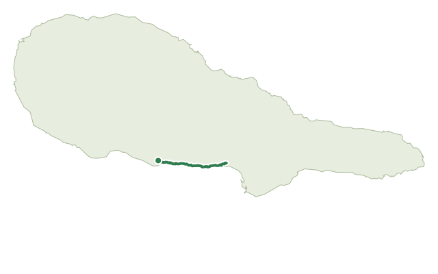
The route starts in the forest reserve and recreation park of Mistério de São João and crosses the broken lava fields — the "mistérios" — left by the eruptions of 1718 and 1720, ground so strange to islanders at the time that it gave the area its name.
Along the way you pass old tide wells at Baía do Arruda, Ponta do Admoiro, Verdoso and Maré do Rego, the restored Ponta Rasa windmill from 1949, and the Casa do Pico and "O Alvião" museum, where you can learn about the island's traditional farming families and São João cheese.
The coast itself offers several natural pools — Ponta do Admoiro and the bathing spots of Arinhas and Fonte are worth a swim if you have time — before the trail passes the Império do Espírito Santo and the churches of São João and São Bartolomeu, finishing in Silveira.
At 8.5 km and about 3 hours, with roughly 450 m of climbing spread across the lava fields, the effort is moderate for an "easy"-rated route — budget time for the museum and a swim rather than rushing it.
Elevation · from the official GPX
Up and down the trail
Plan your walk · MET Norway & IPMA
When to go
Pick a start time. We forecast where you'll be each hour — 0 m at the lowest point, 76 m at the top.
Official facts, our words
What to know
Trail facts
Difficulty Easy- Length
- 8.5 km
- Duration
- 3 hr
- Elevation gain
- 452 m
- Route
- Linear
- Highest point
- 76 m
- Steepest climb
- 15% at km 8.0
- Start
- Mistério de São João Forest Reserve
- Finish
- Church of São Bartolomeu, Silveira
- Permit
- Not required
- Trail code
- PR15PIC
Route and facts © Azores trails network (visitazores.com)